carthography- i know how it could work

Have a suggestion or an idea for Life is Feudal: MMO ? Post it here!

Honzadr
 
Posts: 122
Joined: 23 Jun 2014, 10:27
Location: Moravia(CZ)

carthography- i know how it could work

Post by Honzadr » 14 Aug 2014, 20:16

for those who didn´t read my original idea, don´t even bother. :D

so here is the idea
you will have a new skill(other skills)-Carthography
with this skill you can make maps
to make a map you need ink(made from oak balls) and a surface
you have 3 surfaces
-thin animal skin
-linen cloth
-vellum(crafted out of thin leather)

how much detailed the map is depends on carthographer´s skill(and minigame?)-materials are purely for good look and RP
if the map is good enough, you can make notes in it(very good map) and mark locations

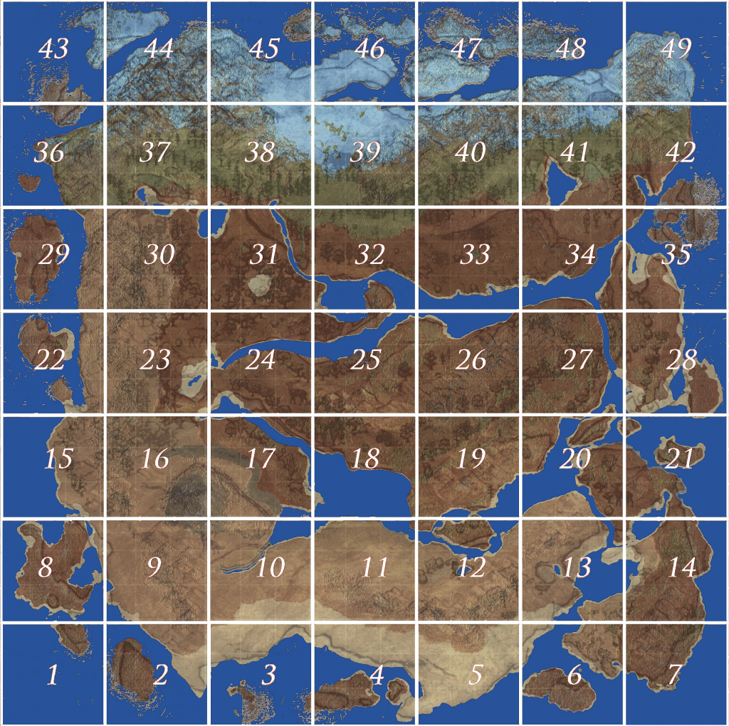
when cartographer is making map he can choose to make-world map, or 1-49 map

world map is simplest and first map carthographer can make
Image
other maps are more specific about location they show
Image

carthographer can also craft optical devices(magnifying glass(map zoom),telescopes)
primary material for these devices is lens
but lenses can not be crafted in furnace, lenses have to be made out of rock crystal(obtained the same way as (semi)precious stones) and then shaped using sand(and finished with chalk)
and the thing that can´t be missing if we talk about maps is compass, but magnetite could make problems to developers, so to make it more simple- it can be rare drop from iron ore block ;)

new items:
oak ball>dried oak balls>oak ball dust
ink(oak ball dust+cherry resin+water+chunk of iron+wine+honey)
vellum(crafted out of thin leather)
magnetite(rare drop from iron ore blocks)
rock crystal(rare drop from stones?)
chalk(if flux is used instead of lime stone, i think this could be replaced with it too)
lens(rock+sand>(rough) lens)
(rough lens +chalk>lens)


Siegbert
Alpha Tester
 
Posts: 1368
Joined: 02 Nov 2013, 15:15
Location: Germany

Re: carthography- i know how it could work

Post by Siegbert » 14 Aug 2014, 21:00

Did you draw this? Looks great!

I would like to have hand drawn maps only but I think there will always be the interactive map in the game. They don't seem to shy away from it.


Honzadr
 
Posts: 122
Joined: 23 Jun 2014, 10:27
Location: Moravia(CZ)

Re: carthography- i know how it could work

Post by Honzadr » 14 Aug 2014, 21:52

Siegbert wrote:Did you draw this? Looks great!

I would like to have hand drawn maps only but I think there will always be the interactive map in the game. They don't seem to shy away from it.

lol. no http://lifeisfeudal.com/category/4
but i don´t get it, if they have the map of LiF world,why we can´t use it in game

they could simply divide it into 49 pieces and add a bit more details :pardon:

User avatar
Thokan
Alpha Tester
 
Posts: 390
Joined: 09 Dec 2013, 15:26
Location: Öland, Sweden. ATS

Re: carthography- i know how it could work

Post by Thokan » 15 Aug 2014, 07:52

This has been discussed many times over. There is no need to implement such a skill when the in-game map is necessary and essential already as it is.
Image


Proximo
Alpha Tester
 
Posts: 461
Joined: 31 Dec 2013, 01:22
Location: Among the Shadows

Re: carthography- i know how it could work

Post by Proximo » 16 Aug 2014, 00:53

Not to mention a cartographer makes maps from scratch and would not be able to draw the entire world map without traveling to every corner and physically mapping out the locations.


Honzadr
 
Posts: 122
Joined: 23 Jun 2014, 10:27
Location: Moravia(CZ)

Re: carthography- i know how it could work

Post by Honzadr » 16 Aug 2014, 08:48

Proximo wrote:Not to mention a cartographer makes maps from scratch and would not be able to draw the entire world map without traveling to every corner and physically mapping out the locations.

http://lifeisfeudal.gamepedia.com/Native
that´s how. plus players are practically colonizers(new world) of LiF world, so it´s only about lore-when they started to build main city, they sent scouts to map the new land and spread plants and animals from their homeland(as all sailors did during exploration of Caribbean) ;)

you need to map the land only once and then people have to remember it.

And what is difference between having a map,that would be explained by lore and shows you whole continent vs. showing you things that are kilometers ahead with 100% precision

and again I am not a fan of chip with google earth on it, implanted to character brain and receiving signals from satellite, so you know where exactly you are. Yes that is how it looks like and i hope that it is just temporary solution.


Siegbert
Alpha Tester
 
Posts: 1368
Joined: 02 Nov 2013, 15:15
Location: Germany

Re: carthography- i know how it could work

Post by Siegbert » 16 Aug 2014, 09:20

What do the natives have to do with it?


Honzadr
 
Posts: 122
Joined: 23 Jun 2014, 10:27
Location: Moravia(CZ)

Re: carthography- i know how it could work

Post by Honzadr » 16 Aug 2014, 11:02

Siegbert wrote:What do the natives have to do with it?

from the word "native" i expect that they are some kind of primitive culture, that lives in caves, or any other hole in ground

and if i am right and they are really humans, they probably have some kind of communication(body language, could help get some information)

and if they are technologically at least at level of native Indians(historically), they surely have maps and one of the scouts could find one, but as i said, it is all about lore.


Siegbert
Alpha Tester
 
Posts: 1368
Joined: 02 Nov 2013, 15:15
Location: Germany

Re: carthography- i know how it could work

Post by Siegbert » 16 Aug 2014, 11:57

I doubt that primitive cultures were ever cartographers. Earliest cartographers in human history were the Greeks afaik.

Medieval maps were hardly accurate as well... Most depict the world as being round with Jerusalem being the center. At least the Western ones did.


Jetcutter
Alpha Tester
 
Posts: 18
Joined: 04 Apr 2013, 15:08

Re: carthography- i know how it could work

Post by Jetcutter » 16 Aug 2014, 12:13

Earliest known maps

The earliest known maps are of the heavens, not the earth. Dots dating to 16,500 BC found on the walls of the Lascaux caves map out part of the night sky, including the three bright stars Vega, Deneb, and Altair (the Summer Triangle asterism), as well as the Pleiades star cluster. The Cuevas de El Castillo in Spain contain a dot map of the Corona Borealis constellation dating from 12,000 BC.[2][3][4]

Cave painting and rock carvings used simple visual elements that may have aided in recognizing landscape features, such as hills or dwellings.[5] A map-like representation of a mountain, river, valleys and routes around Pavlov in the Czech Republic has been dated to 25,000 BP[citation needed], and a 14,000 BP polished chunk of sandstone from a cave in Spanish Navarre may represent similar features superimposed on animal etchings, although it may also represent a spiritual landscape, or simple incisings.[6][7]

Another ancient picture that resembles a map was created in the late 7th millennium BC in Çatalhöyük, Anatolia, modern Turkey. This wall painting may represent a plan of this Neolithic village;[8] however, recent scholarship has questioned the identification of this painting as a map.[9]

Whoever visualized the Çatalhöyük "mental map" may have been encouraged by the fact that houses in Çatalhöyük were clustered together and were entered via flat roofs. Therefore, it was normal for the inhabitants to view their city from a bird's eye view. Later civilizations followed the same convention; today, almost all maps are drawn as if we are looking down from the sky instead of from a horizontal or oblique perspective. The logical advantage of such a perspective is that it provides a view of a greater area, conceptually. There are exceptions: one of the "quasi-maps" of the Minoan civilization on Crete, the “House of the Admiral” wall painting, dating from c. 1600 BC, shows a seaside community in an oblique perspective.

Source: http://en.wikipedia.org/wiki/History_of ... known_maps


Siegbert
Alpha Tester
 
Posts: 1368
Joined: 02 Nov 2013, 15:15
Location: Germany

Re: carthography- i know how it could work

Post by Siegbert » 16 Aug 2014, 12:50

Well, I was talking about maps containing considerable distances, like different towns or countries. But apparently Babylonians did it already, so fair point.


Honzadr
 
Posts: 122
Joined: 23 Jun 2014, 10:27
Location: Moravia(CZ)

Re: carthography- i know how it could work

Post by Honzadr » 16 Aug 2014, 15:16

i though about this carthographer has to see the what he is drawing and i think how this could work

if carthographer wants to make detailed map of sector7(example) he/she has to get into that sector and once he is inside(*few km away from its borders, or at highest point of that sector) he can draw a map of that sector


Proximo
Alpha Tester
 
Posts: 461
Joined: 31 Dec 2013, 01:22
Location: Among the Shadows

Re: carthography- i know how it could work

Post by Proximo » 16 Aug 2014, 22:09

Instead of wasting skill points on this skill I would just reference one of the online maps.

Return to Suggestions and Ideas